
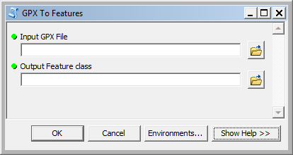
You are a runner and you use a tool such as beautiful as Runtastic, Runkeeper, Garmin, or Endomondo, to track your performance (I personally use Runtastic). After having run thousands of kilometers, you came to the idea to spot your tracks on a map. You can use the build in-tools in the Runtastic Webapplication but what if you want to create your own map(s) ? The data can be downloaded in GPX format from your Sports App Website and can be imported into ArcGIS for Desktop thanks to the GPX to Features tool. It is available for all product versions (Basic, Standard and Advanced).
And now?
Now we’re gonna exploit our exportation and do a nice map! What I did was to
- Use the Points To Line tool in order to connect the dots
- Create a Route layer to add the M-value
- Create a nice style by adding also hatching
- Adding a great underlying basemap (here OSM)
And here the result! (Notice I am living in Brussels and one of my favorite track is running around the King’s Palace in Laken)
