
According to the CIA World FactBook, the ten countries with the longest coastline are the following (when we take into account Greenland and Antarctica of course):
- Canada 202 080 km
- Indonesia 54 716 km
- Greenland 44 087 km
- Russia 37 653 km
- Philippines 36 289 km
- Japan 29 751 km
- Australia 25 760 km
- Norway 25 148 km
- United States 19 924 km
- Antarctica 17 968 km
- New Zealand 15 134 km
- China 14 500 km
But, if we base our analysis on the data coming from the World Resources Institute, we get the following list:
- Canada 265 523 km
- United States 133 312 km
- Russia 110 310 km
- Indonesia 95 181km
- Chile 78 563km
- Australia 66 530km
- Norway 53 199km
- Philippines 33 900km
- Brazil 33 379km
- Finland 31 119km
This list IS VERY different from the other list. If I had taken a third source, I would have gotten a third different result…
How come ?
The two lists are different because the CIA World Factbook takes the countries in their different subparts: Greenland is detached from Denmark, all the overseas territories of France are measured apart from the mainland, etc. The World Resources Institute measures the coastlines of the countries INCLUDING overseas islands. This is one difference. But this is only a part of the story …
The other part is the methodology used to measure coastlines.
Methodology for measuring?
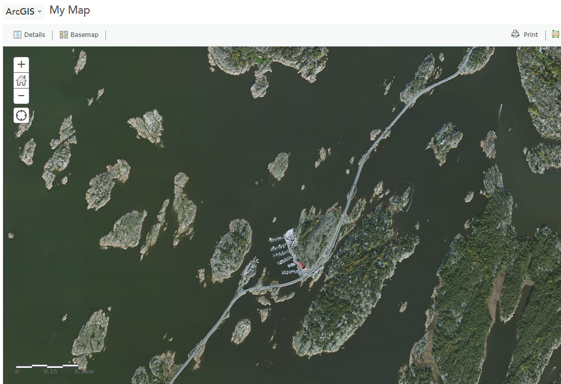
That’s correct! Let’s take the beautiful country of Norway and let’s measure its coastline using ArcGIS Online:
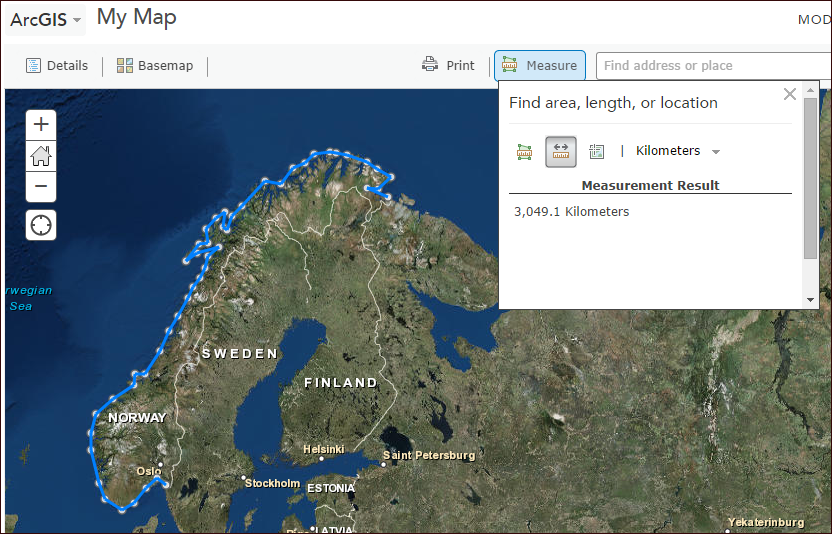
Roughly drawn, the line indicates 3 049.1 km. The CIA World FactBook indicates 25 148 km.
What ?!
Ok, I was not so precise as I draw the line. Let’s make the exercise again but draw the line more precisely:
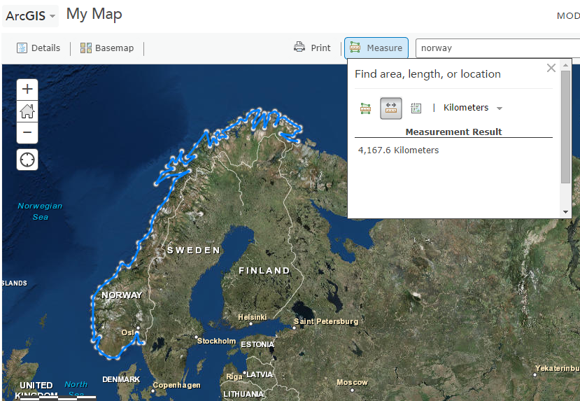
Now we get 4 167.6 km … still far way from the 25 148 km.
The methodology we use is visibly not the best one. The key here is the scale! We are drawing our line a scale which is far too small.
What happens if we zoom in?
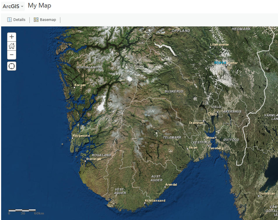
There are a lot more details as you see! So my coastline should be drawn again by taking into account the new details that come up.
Zooming in much more:
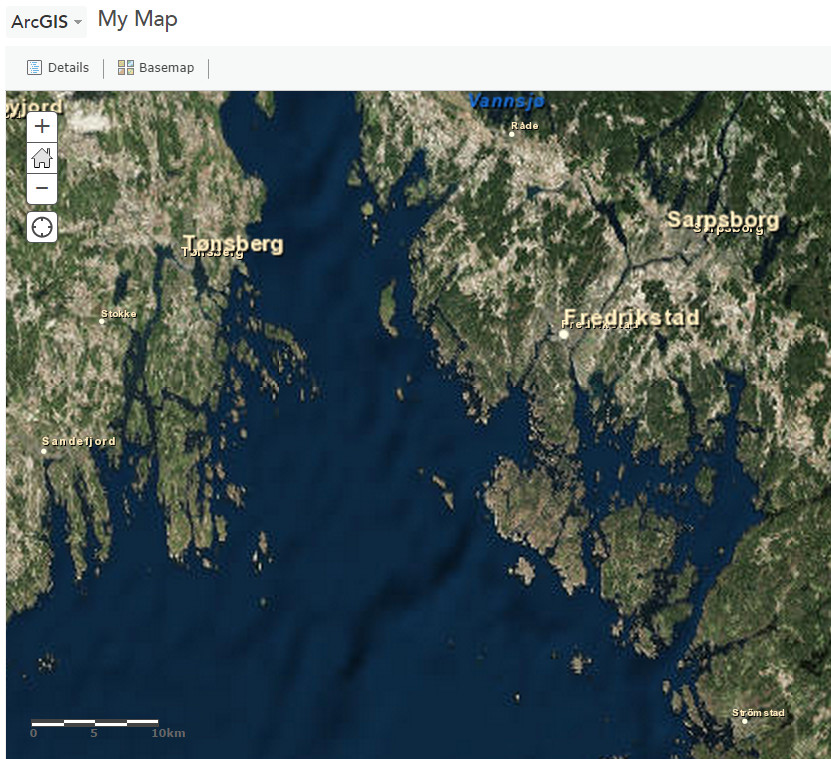
Result? Much more details and an enormous more work for us if we want to measure the coastline!
Zoom in one more time!
So, for measuring the most precisely a coastline, do I have to take into account all the little islands, the cracks, the fjords, etc. ?
THAT’S CORRECT!
For my two tries to determine the length of the coastline, the first, less precise, indicated 3 049.1 km while “the little more precise” was 4 167.6 km. I would have had an even bigger number as long as I zoom on (but I have not my entire day ahead of me for digitizing the coastlines at each zoom level).
What if I had measured the coastline by zooming even more in until I come to the level of atoms ? The coastline of Norway would then be infinite! This is called the coastline paradox and here we get it!
Coastline Paradox
By changing the zoom level, I make appear more details on the map. That’s one points. The second point, I change my degree of precision. At my first try of digitizing the coastline, I used straight lines which were about ~100km long. At my second try (more precise), straight lines were about ~50km at smallest. The more I zoom in, the more precise I can be. Precision here is the length of the straight lines I used to measure the coastline.
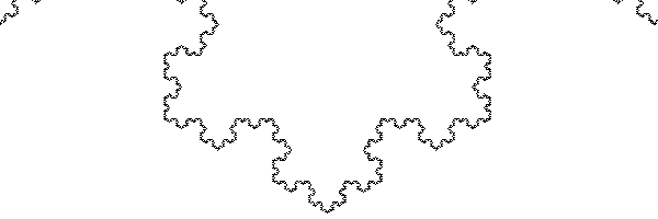
The coastline paradox is in fact a fractal problem in which the total length becomes more and more larger as much details becomes clear as we zoom in. Here a quick example of a fractal (the Koch Snowflake):
Benoit B. Mandelbrot worked on this paradox and released in 1967 a paper called “How Long Is the Coast of Britain? Statistical Self-Similarity and Fractional Dimension“.

As you can see on the picture, if the unit of measure becomes smaller, so larger become the total coastline!
Just a little precision: The “B” in the name “Benoit B. Mandelbrot”, stands for “Benoit B. Mandelbrot”, which “B” stands for “Benoit B. Mandelbrot”, which “B” stands for “Benoit B. Mandelbrot”, … funny isn’t it 🙂
Conclusion
The answer to the question “How long are coastlines?” is: undefined! (if you write this answer down in your geography exam when asked “How long is the coastline of whatever not-landlocked Country” you’ll surely get an 10/10 or an A). And neither the CIA World Factbook nor The World Resources Institute tells what they use as unit of measure.
So what would be determined as the base line for legal bounderies mesurment? I.e for teritorial water or international bounderies in the sea.
Interesting read. I would say it basically depends on the level of “straightness” of your coastline often represented by the Sinuosity Index in the case of a river (http://en.wikipedia.org/wiki/Sinuosity). For instance, whatever the zoom level you’re using, you should see little to no difference with the Belgian coast (almost a straight line – SI close to 1).
Interesting subject for a thesis 🙂
What is known is that the CIA World FactBook numbers and scales used vary for all countries, thus making comparing the numbers worthless. To say the relatively tiny country of New Zealand has over 3/4’s the coastal area of the United States is laughable.
The World Resources Institute uses the SAME scale and methodology for measuring all countries coastlines, making for a MUCH more accurate comparison.