
Placenames in Belgium and the cultural influences
Belgium is a very small country in the Western part of Europe. It lies between The Netherlands, Germany, Luxembourg and France. Despite being so small – around 30 528 km²/11 787 sq mi or the size of Massachusetts – it has a marvelous cultural landscape and has successively received, along history, Celtic, Latin, Germanic, Saxon, Dutch, French and German influences.
These influences have shaped the toponyms (placenames) and it is still possible today to retrace the origins of most names of villages and towns. The origins are often seen in the suffixes and this leads us to think that all places with similar suffixes have the same origin. This is often true but not always.
Nowadays, most of the place names very strongly influenced by the language region they are located in. Belgium has 3 national languages: Flemish (spoken in the Northern part of Belgium), French (spoken in the Southern part), and German (spoken in the Eastern part). Brussels is considered being bilingual (Flemish and French) but most of the inhabitants speak French.
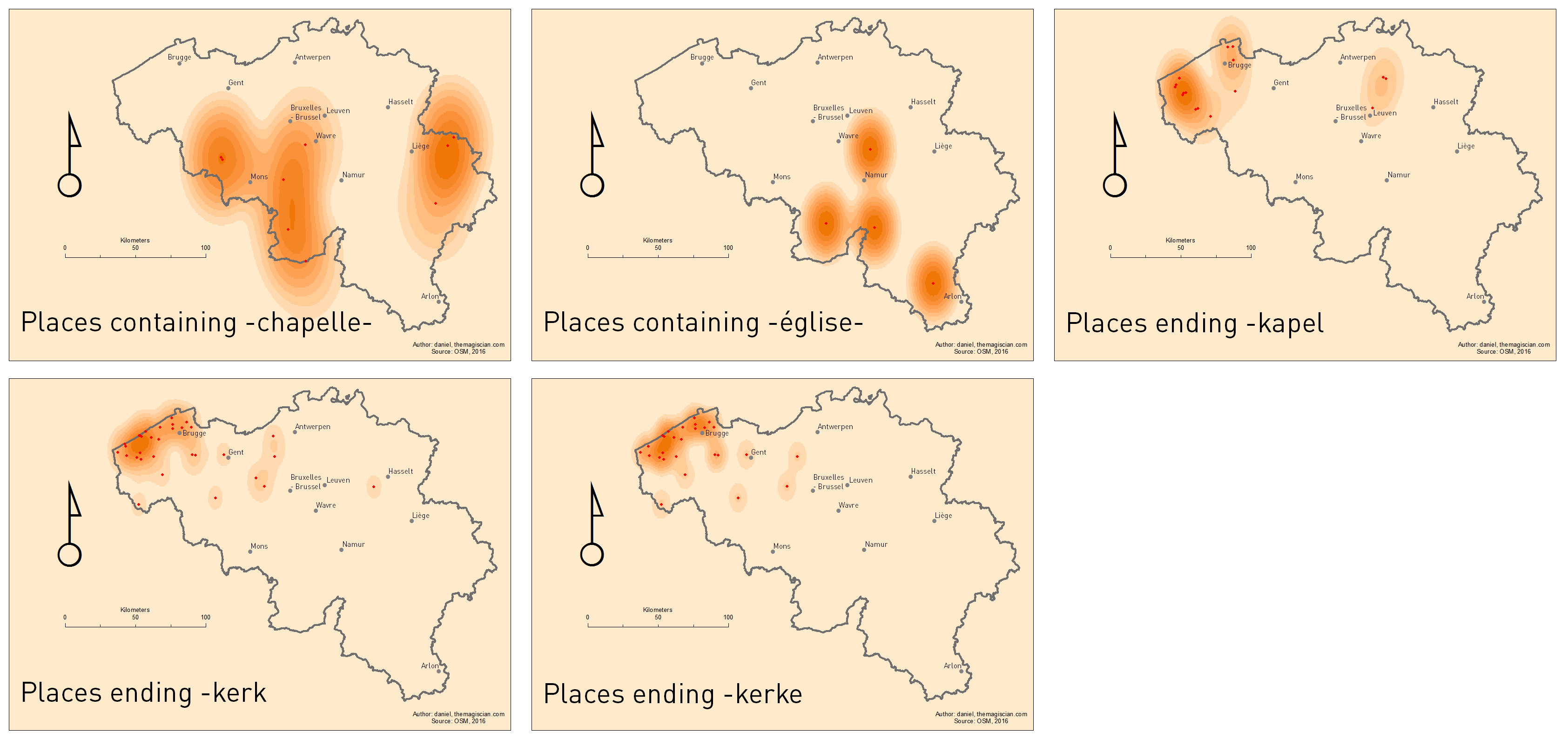
In this articles, we focus on villages and towns containing the sacred word “Saint” (and Dutch and German variation Sint and Sankt), but also other holy places containing holy words such as “Chapelle” (chapel in French), “Eglise” (church in French), “Kapel” (chapel in Flemish), “Kerk” (church in Flemish) and the West Flemish derivative “Kerke“.
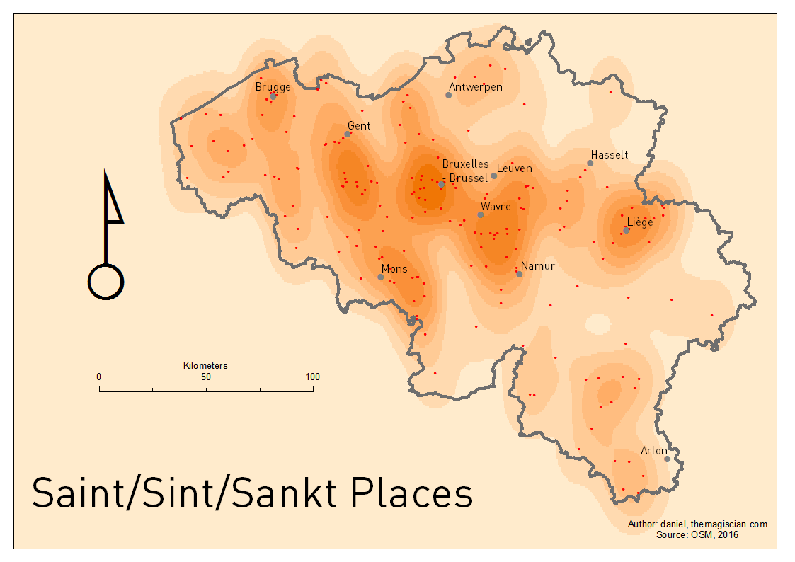
Each dot represents a place.
Meaning
In Belgium, the dominant religion was (and still is) Christianity. 65% of the population adheres to (source: the CIA World Factbook), and this huge religious influence is also visible in place names over time.
The Villages starting with a “Saint” (in French), “Sint“(in Dutch) or “Sankt” (German) are very common. The places are named after biblical characters that are referenced at these places.
The names “Chapel” and “Church” in French and Flemish version are also quite well spread accross the country.
Distribution
Saint/Sint/Sankt
195 places names are sacred in Belgium and they have a good distribution accross the country. Big cities such as Brussels, Wavre, Bruges, Gent, Mons and Liege are well surrounded. There’s however a kind of “no man’s” belt crossing the country from South-West to North-East. Interestingly, only one town in the German speaking part of Belgium contains the “Saint” word: Sankt-Vith (named after Vitus).
Other famous places are
- Berchem-Sainte-Agathe (a Christian saint and virgin martyr)
- Saint-Hubert (from Hubertus, a bishop in Liege)
- Saint-Josse-ten-Noode (a Breton noble)
- Saint-Léger (comes from Leodegar of Poitiers, a martyred Burgundian Bishop of Autun)
- Saint-Nicolas
- Sainte-Ode (associated with eye illness, a statue of the Saint is located near a water source in the village where miners washed their eyes after work)
- Sint-Martens-Voeren (Saint Martin who shared his coat with the poor)
- Sint-Niklaas
- Sint-Pieters-Leeuw
- Sint-Stevens-Woluwe
- Sint-Truiden (named after Trudo who cured a woman of blindness – she became blind after she stumbled over a small church Trudo was building with stones)
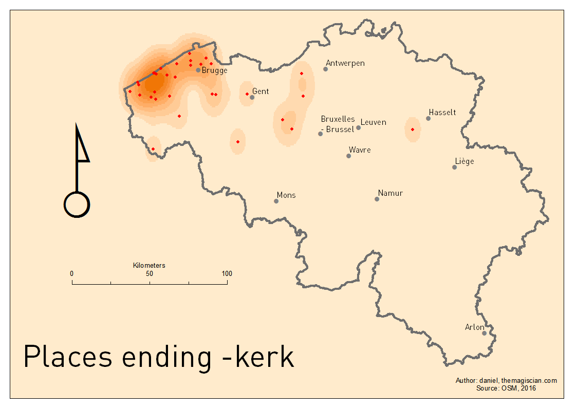
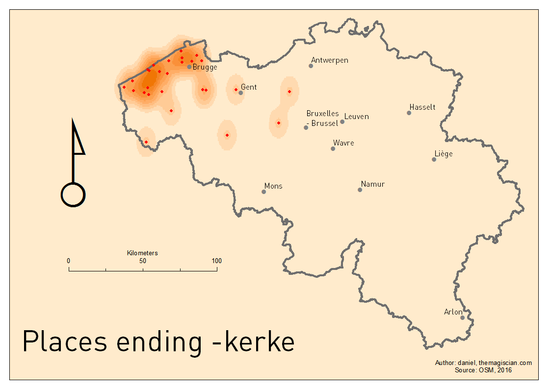
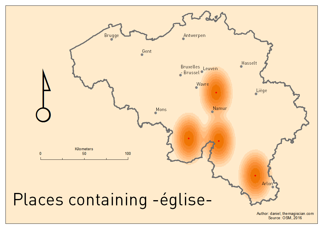
Eglise/Kerke/Kerke/Kirche
They all mean “church“. Eglise is the French wor, Kerk and kerke are in Flemish and Kirche obviously is German.
4 villages contains “église” in their names:
- Autre-Eglise
- Léglise
- Mesnil-Eglise
- Villers-Deux-Eglises
The words Kerk and Kerke are more common in Flanders.
- 32 villages has “kerk” or “kerke” in their names
These are mainly concentrated at the Belgian coast.
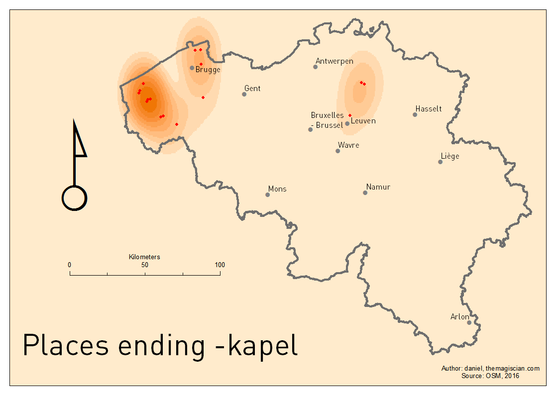
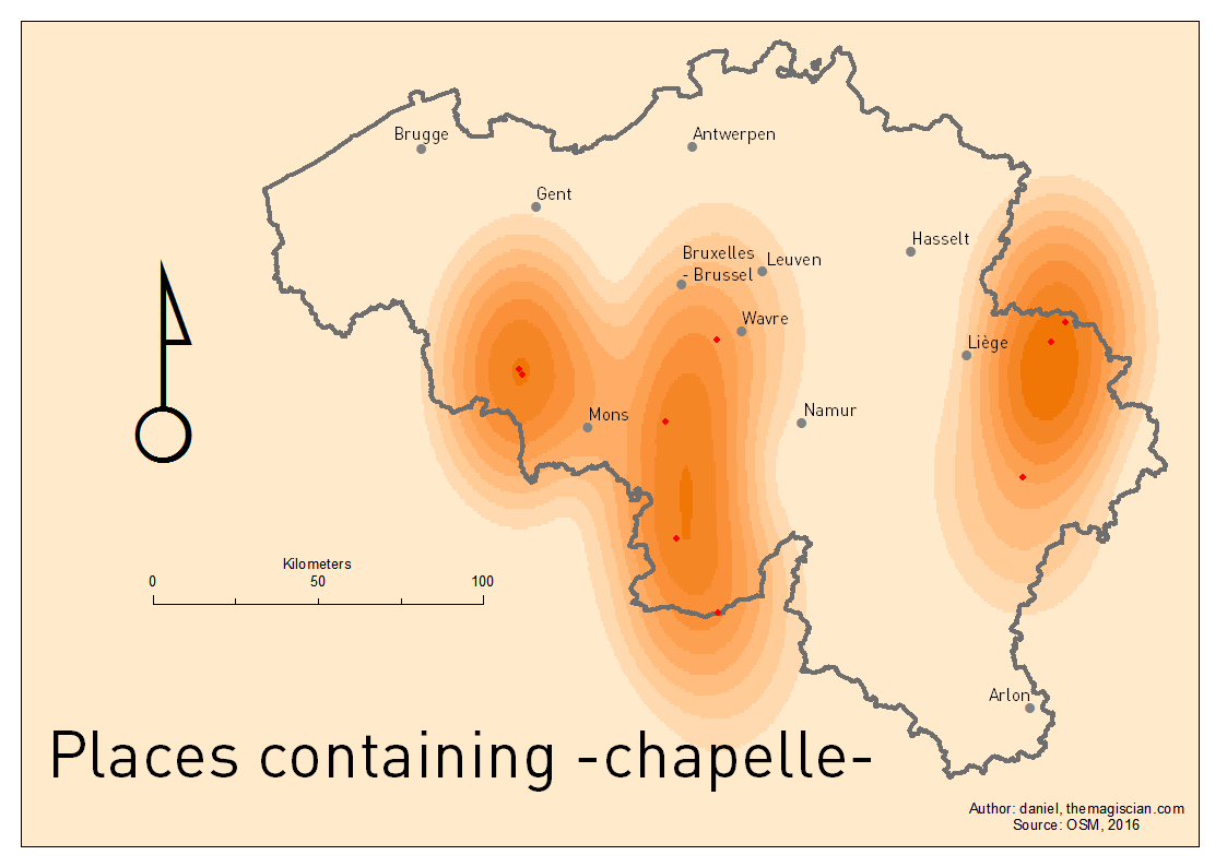
Chapelle/Kapel
As for “kerk”, the “kapel” word is mainly present in West Flanders. “Chapelle” words are not so very spread accross the French speaking part of the country in the South.
40 villages have either Chapelle or Kapel in their names.
Technical Recipe : How to create these maps
The recipe is very simple
- Get raw data from OpenStreetMap
- In a Desktop GIS tool (ArcMap 10.2 has been used), filter the places based on their names
- Run a Kernel Density Geoprocessing
- Apply a symbology
- Define the layout and print !
- Do the workflow again for applying other filters
Get raw data from OpenStreetMap
OpenStreetMap makes it possible to filter and to download lots of information. So is it possible to get place names.
I used the Overpass Turbo website, I went to Belgium and I sent following request (the bbox was [bbox:50.6,7.0,50.8,7.3]):
[out:csv("is_in:continent","is_in:country_code","is_in:province",name,"name:de","name:fr","name:nl",::"lat",::"lon")];
(
 node[place=town]({{bbox}});
 node[place=municipality]({{bbox}});
 node[place=city]({{bbox}});
 node[place=borough]({{bbox}});
 node[place=suburb]({{bbox}});
 node[place=quarter]({{bbox}});
 node[place=neighbourhood]({{bbox}});
 node[place=city_block]({{bbox}});
 node[place=plot]({{bbox}});
 node[place=town]({{bbox}});
 node[place=village]({{bbox}});
 node[place=hamlet]({{bbox}});
 node[place=isolated_dwelling]({{bbox}});
 node[place=farm]({{bbox}});
 node[place=allotments]({{bbox}});
 node[place=name]({{bbox}});
);
out body;
>;
out skel qt;
The parameters:
- Output format: csv
- Attributes I am interested in:
- is_in:continent, is_in:country_code, is_in:province, name, name:de, name:fr, name:nl, latitude, longitude
Conversion and Filter in a Desktop GIS tool (ArcMap 10.2)
The raw csv file that was downloaded has to be converted to a geographic data. I used the Create Feature Class > From XY Table to convert it into a Feature Class.
The filter is applied via a Definition Query:
- Right-click on the data > Properties
- Definition Query
- Type in i.e.: name LIKE ‘%Sint%’ or name LIKE ‘%Saint%’ or name LIKE ‘%Sankt%’ or name LIKE ‘%sint%’ or name LIKE ‘%saint%’ or name LIKE ‘%sankt%’
From this layer, I made a copy and named it after the suffix being analyzed (i.e. ENDING_BEEK)
Run a Kernel Density Geoprocessing
The Kernel Density calculates a magnitude per unit area using a Kernel function. The result is a tapered surface representing the density of points.
The parameters I used are these one:
- Output cell size: 8,0203E-03
- Area Unit: SQUARE_MAP_UNITS
- Output values: DENSITIES
- Method: Planar
Apply a symbology
The default symbology applied to a Kernel Density result is blue. I changed it to a orange scale symbology.
Define the layout and print !
The layout is a A4 format with all the basic and necessary cartographic elements: North Arrow, Frame, Scale, Title, Author, etc.
Do the workflow again for applying other filters – Automation
The filter has to be applied manually by hand (or you can define a Python script doing the job for you). I created 3 groups in the Table of Content:
- STARTS, for towns and villages analyzed based on the prefix
- ENDS, for towns and villages analyzed based on the suffix
- CONTAINS, for towns and villages analyzed based on common words inside of their names
For the Kernel Density geoprocessing, I created a small Python script to bring automation in the process for all the maps.
Applying the symbology to all layers has also been automatized via this Python Script (In fact, I take an already existing symbology and I apply it to all the others).
Bibliography
http://www.eupedia.com/belgium/belgian_place_names.shtml
https://en.wikipedia.org/wiki/Toponymy