
The catchment area of a store is its nearby surroundings where the customers are living. If we take into account the Reilly’s law of retail gravitation, “customers may be willing to travel longer distances to larger retail centers as long as they are large enough” (source:Wikipedia). This model supposes other constraints such as the area around the store being flat, there is no barriers (rivers, mountains, etc.), which is not the case in real life but the model can predict very interesting and accurate results anyway.
IKEA stores have proportionally bigger catchment areas. This is because the stores are big, there are a lot of choices of furnitures, they are cheap and of good quality, there is a good customer service, it also offers other services on place such as children playground, dining service, and there is a good delivery service as well.
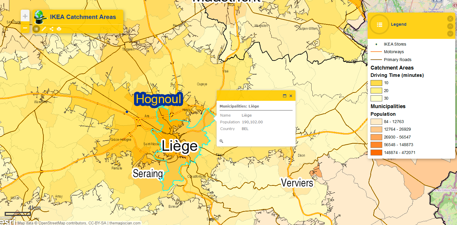
So let just assume people are willing to spend a maximum of 30 minutes driving to the nearest IKEA. These 30-minute driving time, as well as the 10 and 20-minute driving time, are represented as isochrones (lines from where it takes the same amount of time to go to the same point). This is a common tasks performed in the geomarketing field to spot the customers on a map (but can also be used to spot the competitors!). CLICK on the image to get to the Web Application!
For the technical part, the road data used come from OpenStreetMap and the IKEA locations come from the IKEA website. The software used to perform all the calculations and the mapping part is ArcGIS for Desktop (with Network Analyst).
Analyses
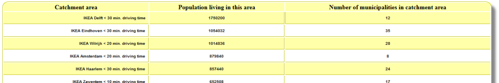
As we can notice, the Benelux Region is very well covered by all these catchment areas. What population it represent? From our analysis, 21 496 663 people live in an area that is less than 30 minutes by car from an IKEA store. The total population of the Benelux Region is 27 689 995, so 77.63% people are living in these areas. If you are interested in the population per catchment area AND per driving time, please have a look at following page. Click on the image to get to the population table.
What about the “IKEA-free Areas?”
We notice anyway that some parts are not covered at all:
– A big part of South of Belgium as well as the Northern part of Luxembourg
– South East of The Netherlands
– A non-negligible part of the North of The Netherlands
Is it worth putting an IKEA in these areas ?
Are there enough people living there?
I overlaid for this purpose a map of the population in each municipality. They are colored according their population so the redder it gets, the more people are living.
At a first sight, we see the “hole” in Belgium corresponds to areas of lesser dense population. This area is known as the Ardennes and is thus less crowded. We see anyway that there could be some substantial potential with the uncovered cities of Namur (107 000 inhabitant), Charleroi (201 000 inhabitant), Mons (91 000 inhabitant), Tournai (68 000 inhabitant).
Maybe are there IKEA in the neighbour countries very near to the border?
From the IKEA France website, we see there is a store in … Lille! So Mons, Tournai and the municipalities in this areas are drained by this foreign store. No worries for the IKEA managers, these people are well served.
What about the East side of The Netherlands?
From the IKEA Germany website, we see that there is a bunch of IKEA stores not so far away: Duisburg, Düsseldorf, Kaarst (the nearest).
What about the travel time?
This is an interesting thing we can notice from the webapp. All the IKEA stores are located near Highways and especially near highway nodes. Accessibility seems to be a keypoint in the IKEA-success-story.
Conclusion
It has been made possible, with the free data provided (OSM, IKEA locations, etc.), and with a GIS tool, to calculate the catchment areas of all the 20 Ikea Stores within the Benelux Region. The Benelux countries are well served by the IKEA stores and some foreign stores covers the remaining holes.
For further discussion on how I did the map, the app, the analyses, processed the underlaid data, etc., feel free to contact me!
Thank you for reading!
Daniel
http://www.ikea.com/ms/fr_BE/about-the-ikea-group/expansion/mons.html
Thanks a lot for this information! They are indeed building this new IKEA store in one of my identified “IKEA-free-hole” 🙂